Yearly Archives: 2017

SUNDAY 5:00AM IRMA update, NHC Advisory #45

NHC 5pm Advisory 43 9-9-17

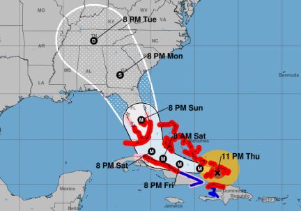
5:00AM IRMA update, NHC Advisory #45. Irma slowed to a CAT 4 as she passed Cuba.  Changes from last advisory in red.
Maximum sustained winds back to 130 (up from 115) at 11:00PM moving NW at 8mph (down from 9mph.)  The pressure is 928 (down from 933.) The lower the pressure, the more powerful, the more potential for tossing stuff around.    Continue reading

This storm will pass, stay strong

Make no mistake, this is a very large and dangerous storm but we’re stronger than we think we are, we may be more prepared than we think we are and we’re doing a lot better than we think we are. I make these updates because I like to know the location and storm specs without hearing inflammatory commentary. If I watch it, the sound is off. When I can see it for myself without listening to someone else’s opinion, it gives me the time and space to contemplate what it might mean for me. When I halt everyone else’s comments, it allows my mind to relax enough so I can hear my inner guidance. When I can release resistance and follow inner guidance, I always end up in the right place at the right time.

IRMA 5:00PM update, NHC Advisory #43

NHC 5pm Advisory 43 9-9-17

WFTV reports Irma is predicted to hit the Central Florida region as a Category 2 hurricane, with winds 96-110 mph.

5:00PM IRMA update, NHC Advisory #43. Irma slowed to a CAT 4 as she passed Cuba.  Changes from last advisory in red.
Maximum sustained winds 115, down from 130 at 2:00pm moving WNW at 9mph, down from 12 mph.
The pressure is 933, down from 937. The lower the pressure, the more powerful, the more potential for tossing stuff around. Basically all of Florida is going to get hurricane force (74 mph+) winds as it passes your area. Florida homes are built for this.    Continue reading

IRMA 8:00AM update, NHC Advisory #41-A

8:00AM IRMA update, NHC Advisory #41A. Irma slowed to a CAT 4 as she passed Cuba. Maximum sustained winds 130, down from 155 moving WNW 12 mph, pressure is 937, up from 930. Rising is good. The lower the pressure, the more powerful, the more potential for tossing stuff around. Basically all of Florida is going to get hurricane force (74 mph+) winds as it passes your area. But Florida homes are built for this. NHC reports the center of Irma will move near Cuba today, near the Florida Keys Sunday morning, then near the SW coast of Florida Sunday afternoon. Hurricane (74mph+) and tropical storm conditions (39mph+) are possible in central and north Florida by Sunday.    Continue reading

Irma should pass us Sunday

My updates are focused on Palm Bay/Melbourne. Click the links to read the full advisory yourself to see what applies to the area you’re in. The National Hurricane Center 8:00pm Advisory 39A shows Irma near the Florida Keys Sunday morning. Hurricane force winds (above 74mph) extend outward up to 70 miles from the center. Tropical storm force winds (below 74mph) extend outward up to 185 miles. We’re now under hurricane watch as well as storm surge watch. A Storm Surge Warning means there is a danger of life threatening inundation, from rising water moving inland from the coastline, during the next 36 hours in the indicated locations. For a depiction of areas at risk, please see the National Weather Service Storm Surge Watch/Warning Graphic, available at http://hurricanes.gov.  A Storm Surge Watch means there is a possibility of life-threatening inundation in the indicated locations during the next 48 hours.   Continue reading

Irma may hit near Miami Sunday, near Atlanta Monday

NHC Advisory 11:00pm 9-7-17

It is looking more and more as though Irma will be a repeat of Hurricane Matthew last year, which was very doable. The latest news has Irma dropping speed, down to 165 from 185, and landing near Miami sometime Sunday. NHC says about 8pm, James Spann says just after midnight Saturday. We’ll know more in 24 hours. It looks now like she’ll go up the center of the state to land as a Cat 2 near Atlanta.     Continue reading

Here’s what the world’s most accurate weather model predicts for Irma 

Here’s what “the world’s most accurate weather model” predicts for Irma. In recent years, the European Center for Medium-Range Weather Forecasts has the best forecast model in the world, often generating the best forecasts for hurricane tracks. In some cases, during Hurricane Harvey, it even exceeded the skill of human forecasters at the National Hurricane Center.  https://arstechnica.com/science/2017/09/heres-what-the-worlds-most-accurate-weather-model-predicts-for-irma/     Continue reading

After what Hurricane Irma did to the Caribbean, we’ll be fine

St. Maarten after Hurricane Irma. 

I’m hopeful for Florida after glancing at the photos of the Caribbean islands the day AFTER being directly hit by Irma as a CAT 5.  The photos are encouraging because even though the news says it is “complete devastation,” it is NOT as there are a LOT of buildings still standing or partially standing. They were hit head-on as a CAT5 and they have far less stringent building codes than we do. So even if the worst-case scenario happens, which it looks like it will certainly NOT be, get yourself inside a boarded-up home and hang tight. Stay hopeful. Know that miracles happen every day somewhere, might as well be here.   Continue reading

Remember: Hurricane Matthew was a Cat 5 yet we only got 109 winds

Please share to calm unnecessary fears. Hurricane Matthew last year reminds us that a huge Category 5  with 165 winds can come ashore with only 109 winds affecting us. That can happen here, too. Hurricane Matthew was a Cat 5 and began disspating and slowing down just before it got to us. When they say a hurricane is 500 miles wide and 185 mph, that doesn’t mean the entire storm is moving 185 mph.  Example: Hurricane Irma, the eye is 25 miles in diameter. A FEW MILES OUTSIDE of that is where the 185 mph winds are. NOT all 500 miles of the entire storm.     Continue reading